Saturday 30 July 2016

Pioneer Railway and Tramway Survey & Construction Auckland Province , NZ 1862 - 1908

Morrinsville - Matamata section - Photo 2008 courtesy Chris Ball 

For some in New Zealand history was given the role of “ Trail Blazer”. - the  early Pioneer engineers and surveyors of the 19th Century. They explored, measured, drew maps and plans and recorded in diaries, reports and papers ,their observations.

 Engineers and surveyors were  involved with  what was then known as Railway and Tramway Survey and Construction in the Auckland Province, New Zealand during the years 1862 - 1908.

 Theirs was the job of preliminary and permanent way surveys; construction of the railway ( formation and permanent way) ; construction of bridges, culverts and drains associated with the railways; Readying the buildings such as goods sheds, signal buildings  and railway stations. They specialised in this field during those early years of railway and tramway construction.

 Unknown photographer
Waihi Railway Station was opened in 1905 - Waihi Station in 2008 photo courtesy Chris Ball 2008
 
The role of the Engineer in charge could be said to have been “problem solver”. It could be said it was a role that needed a “thick skin” and “common sense” approach. Instances of these needed skills were:-
  • An incident with a member of a Survey Party being shot. Messrs Sheehan,  Puckey, Thomson and Stewart  called for and meetings to sort it out - an incident which occurred in a land survey camp impacting on the nearby proposed Thames Waikato Railway route.( Otago Witness 06/09/1879 )
  • A meeting with local settlers over location of station and then terminus of railway - main trunk line at Te Awamutu.
  • The “notorious bridge dispute " near Waharoa on the Morrinsville - Matamata  section I Rotorua Railway with its final diplomatic outcome in the end of dinner speeches given by all parties. A mandate received to take the railway through to the Mamaku and on.( New Zealand Herald  17/08/1885)  
Prices first locomotive ordered 1883 for Piako County Tramway ( AKA Waiorongomai Tramway) Never used on this  Tramway was sold to Smythe Bros timber contractors - drawing ASB

 As well as " problem solving"  there were  all the other things  that went with constructing a railway “ready to go.” It was the engineer in charge and assistant engineer in charge who  organised the purchase and supply of rails , nuts, bolts and plates; ordered sleepers - wooden in those days - thousands of them ; ordered locomotives and rolling stock, organised construction of railway bridges - some little more than a baillie bridge and others a little bigger or complex  such as Ngaruawahia railway bridge, Hamilton railway bridge and Kauaeranga railway bridge.
 
At the end of the day there was only one decision that could be made for the railway route.


early locomotive foreground and Helensville Station background photo 2011 - photo courtesy Chris Ball

On the Railway Route

The Railway engineers and surveyors were often away from  home for  days, weeks and sometimes months. Often there were no roads on  the routes they were taking for this was "raw terrain " - They were finding the “best route” for a railway.
  • Night base was a tent or “blanket roll" in the bush.
  • Early days of travel from Auckland  Southwards and Eastwards  was by steamer and horse.
  • A short cut route was used from the Piako  County Tramway  ( AKA Wairongomai Tramway) near Te Aroha through to the foothills of the Mamaku, where the Rotorua Railway was being surveyed.
Battery Remains near Waiorongomai near Mount Te Aroha 2009 - photo courtesy Chris Ball
 

Life in a Survey Camp

  • Railway Engineer Survey  Teams were close-knit. Often lifelong work and friendship links were formed.
  • Food and sleep  after  a day's work  was essential. The terrain was often dense bush, swampy ground.
  • Getting pegs and equipment ready for the next day's work. Writing up day diaries, drawing draft railway maps , checking the days curves and gradients
  •  Conversations, swapping professional ideas and keeping abreast of developments,  chequers and chess.
  • It is known that the Survey Camp was where the dreams of use of this new invention electricity were shared -electric power to run machinery  and a town, electric tramways.
  • There was often a cook preparing the meals for the surveyors.


This sketch is from one of the pen and ink drawings with which Mr. Brookes used to illustrate his letters to his parents in England. It is dated October 31, 1862, and shows the surveyors' camp in the bush between Mangawai and the site of Port Albert, the party to which Mr. Brookes was then attached being engaged in putting

The Terrain faced

Swamps –often in places a bottomless hole that sucked up the ballast ( the original main trunk section Ohaupo - Te Awamutu seemed to suck it up. Towns people could see the railway almost there and could not understand why the process was not quicker. They did not know that before the permanent way could be completed, the swamp holes Had to be filled and levelled in the formation.)

Rivers and Streams – finding the best and most economical route with consideration for flood, tidal and being able to build as few bridges & culverts as possible. As far as possible the product and resources of the area were utilised eg The stone near Rotorua township for culverts.

Culvert ( constructed from local materials ) Rotorua Railway Eruera Street - photo 2005
 
The Eastern Ranges - Spanning the Eastern Coasts of the Auckland Province, NZ ( Coromandel, Kaimai, Mamaku, Urewera) Finding the “best route “with the least difficult construction. problems were hard rock, narrow deep valleys and ravines. A suitable route through the Mamaku for the railway took months.
 
                                           Looking toward the Mamaku Range photo 2010 - courtesy Chris Ball
 

Dense Bush

In parts

Conditions experienced during  construction

 
Snow and Storms -

 Waiorongomai Tramway, Rotorua Railway
 
 Floods -
 Thames, Waikato, Kaipara and Waihi. In 1907 there was flooding that impacted on many of the railway lines, causing widespread damage.
 
 Tarawera Eruption -
 Rotorua Railway
The first NZ attempt to precisely measure earth deformation due to a specific geological event.
 
 
Rock Falls

Karangahake Tunnel, Waihi Railway. Three railway construction workers lost their lives during  this  tunnel's construction.
 
Entrance to railway tunnel Karangahake - now a cycleway on the Hauraki Rail Trail - photo 2012 courtesy Chris Ball
  People Danger
Requiring some good diplomatic skills to avert life  threatening situations.  The “notorious bridge dispute " near Waharoa on the Morrinsville - Matamata  section I Rotorua Railway.

Measurement  tools of railway surveyors

 
There were no  GPS or  computers that we  have today. A Theodolite - essential equipment, also a chain
Theodolite
Measurements taken, were recorded in a daily diary.
Railway maps were drawn by hand,  with curves and gradients in detail


Construction Aids

                
( Certainly nothing like this state of art equipment)
         Modern Track laying equipment - something those early pioneer railway surveyors and engineers did not have - photo 2013  on the Hamilton Morrinsville section of railway courtesy Chris Ball

There were no cranes, computerised cranes  helicopters, Hiab trucks, plate laying machinery back in those early days of railway survey and construction.
Construction aids for  railways, even  in the early 1900s,  were still very labour intensive.  It  was miner’s pick and shovel, lift and carry. Use of horse,  truck, fiddlestick”, and where possible " ballast  train.”  Construction labourers on the railways numbered eighty persons  plus labour force - some experienced in formation, some in permanent way, plate laying, rail laying.


The Railway engineer surveyors


These were the Railway engineer surveyors  of the Auckland Province 1862  - 1908. Some of them were surveyors only, some engineers only and some held qualifications as both engineer and surveyor.
Daniel Manders BEERE
Gerald Butler BEERE
Edward Holroyd BEERE
CARRAND
Peter GRACE
John GWYNNETH
William Henry HALES
J J HAYS
Samuel HARDING
R.W. HOLMES
Ashley John Barsby HUNTER
Duncan William McARTHUR
Charles O’NEILL
Henry ROCHE
John ROCHFORT
Charles SANDERSON
Daniel SIMPSON
S. S. SPRINGALL
James STEWART
James STEWART Jnr
Frederick James UTTING
Charles VICKERMAN
Hugh VICKERMAN
Thomas SHAW

The New Zealand Institute of Surveyors (NZIS) was  originally established in 1888 to monitor and maintain the professional and ethical conduct of surveyors in New Zealand.  Railway Surveyors joined the Institute. Many of them also belonged to the NZ Institute sharing their skills and knowledge, along with writing papers which appeared in the annual Transactions and Proceedings.

The Institute of Local Government Engineers of New Zealand, was formed in 1912.This was the  first New Zealand based professional engineering body.  In 1913  the New Zealand Society of Civil Engineers was formed and both bodies merged in 1914. Railway Engineers were also members of the  NZ Institute. A number of them also belonged to their respective Institute overseas. On the establishment of the New Zealand engineering body many of the Railway engineers became very active as members. It had been a long held dream of many of them to see this happen and a topic of discussion in those early survey and construction camps.
 
The Engineer Volunteer Militia were involved with the construction of the  section Mercer to Ngaruawahia and Ngaruawahia to Te Awamutu. In charge of the construction crew were:-
Major COOPER
Captain HOWELL
Major JACKSON
Captain ROWE
Captain SCHOFIELD
Contractors who constructed the railways are another story - perhaps another blog?
 
                 Some of the measuring tools used by Surveyors & Engineers   Bean Compasses measurement tool in
 

The Railways and Tramways of Auckland Province  constructed 1862 - 1908

  •   Waihoihoi Tramway
  •   Drury Railway
  •   Drury to Onehunga and Mercer
  •   Tararu tramway
  •     Waikato Railway Mercer to Te Awamutu and Kihikihi ( eventual Main Trunk )
  •    Kawakawa to Taumarere
  •     Kaipara - Riverhead
  •      Kaipara railway & Extension  Henderson - Helensville
  •    Cambridge railway
  •    Thames Waikato railway
  •    Paeroa Waihi railway
  •    Whangarei railway
  •    Piako County tramway AKA  Waiorongomai Tramway
  •    Rotorua railway  ( section I Morrinsville - Lichfield ; section II Lichfield Rotorua)
  •    Reconnaisance Survey Gisborne Rotorua railway
  •    Auckland Electric tramway
  •    Last section of the Main Trunk railway
During construction there were many debates about end of routes, gradients, guage (The Public Works policy of 1870, which was to rule all subsequent railway construction in New Zealand, chose 3ft. 6in). which wood for sleepers.
 
Railway and tramways were the technology of the mid to late 1800's and early 1900's. They were the means in a newly settled country to transport more easily goods, produce and people. The Auckland Electric Tramway was said to have surpassed  the dreams and plans of even its promoters and was the means for many years of moving commuters to and from work. The Waihi Railway opening in 1905 made a big difference for the transport of goods and supplies through the Karangahake Gorge to the burgeoning gold mine industrial processing site at Waikino and the town and large goldmine at Waihi.
 
Waihi Railway in 2008 - photo courtesy Chris Ball


A Heritage left for us Today

 
The Railway Engineer Surveyors, as a hobby:-
  • drew or painted pictures or cartoons
  • wrote  papers on variety of topics for professional organisations.
  • took photographs
  • took up wood carving, woodturning, making whip handles ( horses ) - these donated to local fundraising fairs.
  • drew maps
Today some these  are in our National Library, Museums, Archives and other Libraries. Modern day writers, researchers and family historians use and refer to them in their works.
 
  • The photographs and maps of Daniel Manders Beere
  • The maps  and papers of James Stewart
  • The cartoons of Ashley Hunter
  • Henry ( Harry)Roche’s eyewitness account of Tarawera Eruption
  • Papers by Stewart and Hunter in Transactions & Proceedings NZ Institute ( now Royal Society of New Zealand)

A number of the railways have gone or morphed into new uses. Many of the railway and tramway routes today have become tramping tracks or cycle ways.  However the modern users can thank those early surveyors and engineers for it is their work that formed the permanent ways and constructed the foundations of the tracks- sometimes with tons of ballast filling those swamp holes, the culverts constructed way back then.  Yes it is a Heritage Legacy from those Railway engineer surveyors :-
 
        Dreamers and builders of destiny, Makers of steel tracks across Horizon.” ASB
 
Reference Source:
  • FRONTIER TOWN. A HISTORY OF TE AWAMUTU. 1884- 1994 Laurie Barber
  • CYCLOPAEDIA NEW ZEALAND, Vol. 2, Auckland Province
  •  Early New Zealand Engineers, Furkert, F.W., Reed, Wellington, 1953
  • THE PIONEER LAND SURVEYORS OF NEW ZEALAND C. A. LAWN, F. N. Z. I. S,1977.Part III
  • THE PIONEER LAND SURVEYORS OF NEW ZEALAND C. A. LAWN, F. N. Z. I. S, 1977.Part IV
  • LAND OF THE THREE RIVERS – CENTENNIAL HISTORY OF PIAKO COUNTY, Vennell C.W. and More D, Wilson & Horton, Auckland N.Z. , 1976
  • THE FOUNDING YEARS IN ROTORUA – A HISTORY OF EVENTS TO 1900, D.M. Stafford, Ray Richards and Rotorua District Council, 1986


Wednesday 29 June 2016

Hunua Ranges - Years Before and After WWII


Kohukohunui Hunua Ranges 1930s - photo JM Stewart

Following the end of WWII, Jack Stewart moved from the city of Auckland, and became a ranger in the Otau - part of the Hunua Ranges - what is now in and known as Hunua Ranges  Regional Park and the Waharau Regional Park on the Eastern side of the Hunua ranges. 

Jacks home in the Otau Valley, Hunua Ranges  when a ranger in the late  1940's - photo JM Stewart
Hunua Hills in the late 1940's - photo JM Stewart

During the Depression years at the beginning of the 1930's. a thirsty Auckland was eying up the Hunua Ranges, again, for  a possible city water supply. The New Zealand Herald reported on the possibilities of two bountiful rivers  - the Mangatawhiri and the Mangatangi - with an estimated total discharge for the two of 40,000,000 gallons daily. ( NZ Herald 16/01/1930)  According to the article city councillors were also shown possible dam sites for storing water and given information on the possible water supply gathered by others. This presented to councillors by the city waterworks engineer , Mr. A.D. Meads and chairman of the water committee, Mr. A.J. Entrician.

A city water supply from the Hunua Ranges was by no means a new idea. As far back as seventy years previous, in 1860,  Jack Stewart's civil engineer grandfather won a prize for  water supply plans, bringing a supply to the city from Onehunga. At this time a supply from the Hunua Ranges was also mooted and continued to be suggested and the idea explored over the years.  Water supply - both the supply and issue - continued to ebb and flow throughout the following years, with a number of locations utilised. Still not enough supply to sustain a growing city. 

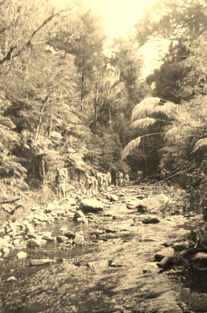
Auckland Tramping Club in Mangatawhiri River Gorge before water supply  in 1930s - photo JM Stewart
Mangatangi River in the 1930's - before water supply - photo JM Stewart

In 1930 , the same time as a suggested water supply from the Hunua Ranges, it was the Depression years. A  large unemployment relief works camp , said to be 100 men,  were going on with major road construction works in the Hunua Gorge.


BIG UNEMPLOYMENT RELIEF WORK NEAR AUCKLAND CITY: ROAD CONSTRUCTION IN THE HUNUA GORGE. Left: One o... [truncated] New Zealand Herald, Volume, 8 February 1930, Page 10
Back in 1922, a water supply from Hunua Gorge was opened to supply the then township of Papakura. The New Zealand Herald reporting on the opening wrote :-

" Mr. McLennan said the scheme had cost £30,000. Owing to the Franklin County Council refusing to allow the board to lay the main on the road a pipe track had to be constructed alone: the precipitous and rocky face on the bush side of the gorge, at a cost of £2500, or £2000 in addition to the estimated cost of the original route. To meet this extra expenditure and also to reticulate the outer areas not originally included in the scheme, the board intended to raise a further small loan in the near future."

Prior to WWII Jack Stewart  enjoyed many a tramping trip to the Hunua's with the Auckland Tramping Club during the 1930's  Close to the  growing city of Auckland, the Hunua Ranges were in easy reach for the tramping club members.

Most members worked Saturday mornings,, including Jack Stewart, who worked in the Manchester Linen Department of Macky  Logan Caldwell , a manufacturing and wholesale merchant supplier.

The Papakura Train was caught to reach the Hunua Ranges, again from Newmarket, as with the Henderson or Swanson train to reach the club's Waitakere base .It was said that these train trips were noisy affairs with many tramping songs being sung with great gusto. Likewise the return and disembarking at Newmarket - not a quiet and orderly process. In 1936 -1937 the Auckland Tramping Club decided to build a hut ( named Te Hapua ,meaning sheltered hollow in the hills.) The hut in those days was of very simple construction made of corrugated iron and Boulders for the chimney.


Te Hapua Hut Hunua Ranges in progress 1936 - 1937 - photo unknown photographer

The Hunua Ranges were seen by the Auckland Tramping Club then, to be  first class tramping area - wide streams, gorges and fine flora including tawa. Earlier years in 1933, the Auckland Star thought this too about the when it reported:-


" A long valley pushes its pretty head eastward from Hunua right to the peak of Kohukohunui, near the Firth of Thames. This is the Valley of the Moumoukai. Its forested sides are superb, and, especially across to the east, this country is the birthplace of clear, sweet, swift-running streams singing their way southward over everwidening' beds. The forest is mainly tawa, with its charming light and shade, but on dry ridges clinker beech may also occur. Just now. in this tawa forest, hinau is in full bloom. I doubt whether there is another area of bush in the country to "compare with it in abundance of hinau. Anyway, in November and December, its huge crowns of creamy Mowers are an unforgettable sight. "
( Auckland Star 16/12/1933) 

Auckland Tramping Club on track beside Mangatawhiri River  before water supply  in 1930s
- photo JM Stewart

It seems that several also took interest in the physiology and geology of the Hunua Ranges area in the 1930s and into the early 1940s. Law wrote and read a paper to the Otago Institute in 1930 and Brown to the Wellington Institute in 1941  ( Transactions  and Proceedings Royal Society NZ )


Auckland Tramping Club crossing stream Mangatawhiri River  before water supply  in 1930s
- photo JM Stewart
Auckland Tramping Club on track beside Mangatawhiri  River before water supply  in 1930s
- photo JM Stewart

Following the war in 1946 the Hunua Ranges were seen as superceding the Waitakere's for tramping. Tramping in the Waitakere's  was considered becoming less isolated by some members than the Hunua area.

Auckland Tramping Club on track beside Mangatangi river before water  supply  in 1930s
- photo JM Stewart

By 1961 the end was tolled for the Te Hapua hut. Dismantled and carried out to make way for the city water supply. A quick look at the Watercare website records five dams in the Hunua Ranges in 2016:-
  • Mangatangi Dam completed 1977
  • Mangatawhiri Dam completed 1965
  • Cossey’s Dam completed  1955 
  • Wairoa Dam completed  1975
  • Hays Creek Dam completed 1967
Mangatangi river before water  supply  in 1930s - photo JM Stewart


The Regional Parks of the Hunua Ranges in 2016 continue to be used for tramping and other recreational activities. The Hunua Falls are a popular place in the summer months. The YMCA Camp Adair ( named for Mr. George W Adair who supervised the annual camps for many years)

Started in 1913, the YMCA camp run for boys was popular during the 1930's. In 1939 - the beginning year of WWII  - saw Camp Adair mark their silver jubilee with a renaming of the YMCA Camp to Camp Adair and the dedication of a new gateway to mark the occasion. 

Jack Stewart's sojourn as a ranger in the Hunua Ranges after the war was only a couple of  years. By 1950 he had moved from Otau to running a country general store at nearby Hunua, then a farm  and another era in his life. Tramping continued, particularly on retirement. Tramping friendships made in those early years of the 1930's were continued throughout life.

Footnote:

Called tramping in New Zealand this recreation is known as hiking in some countries.

The photos used in this blog item were taken over 80 years ago by Jack Stewart, my father. They are a record of an area for that time. With his love of tramping and climbing in New Zealand went a love of photography too.

Reference Source:
  • Furkert, F.W. Early New Zealand Engineers. Wellington: Reed, 1953.pp 271-272
  • The Auckland Tramping Club Inc., 1925 – 1975 50 Years Tramping, The Auckland Tramping Club Inc.,1975
  • Geology of the Papakura-Hunua District, Franklin County, Auckland. By C. R. Laws, M.Sc., Dunedin Training College., from Volume 62, 1931-32 Transactions and Proceedings of the Royal Society of New Zealand 1868-1961
  • Geology of the West Coast of the Firth of Thames. By D. A. Brown, from Volume 72, 1942-43 Transactions and Proceedings of the Royal Society of New Zealand 1868-1961
  • Lyons, R. R., 1932. Notes on Geology of Mangatangi-Mangatawhiri District, Auckland, N.Z. Journal Science and Technology, vol. 13, pp. 268–77
  • Water Supply . Daily Southern Cross,  13 April 1860, Page 3
  • WATER FOR PAPAKURA. New Zealand Herald, 20 September 1922, Page 6
  • BIG UNEMPLOYMENT RELIEF WORK NEAR AUCKLAND CITY: ROAD CONSTRUCTION IN THE HUNUA GORGE. Left: One o... [truncated] New Zealand Herald, February 1930, Page 10
  • Native Wild Flowers. Auckland Star, 16 December 1933, Page 2
  • NEW ENTRANCE GATES AT BOYS* CAMP DEDICATED The new entrance gates which were dedicated yesterday at ... [truncated] New Zealand Herald,, 9 January 1939, Page 6